Old Spanish Missions and Forts of the Southeast
When we think of Spanish missions the Texas and California systems come readily to mind. However, one of the great secrets of American History were the more than 150 eastern mission churches once dotting the landscape between Miami and Chesapeake Bay. Built between the 1560s and 1760s the missions were concentrated in what is now northern Florida and southern Georgia, but until recently their existence and influence on the region's native groups has remained virtually undetected.
"The Spanish probably settled in the area even before the mission was built and certainly long before John James Oglethorpe arrived in Georgia in 1733. The find, (of the mission), will prove the Spanish were the first in the area after the Indians." Dr. Dennis Blanton
Recent excavation by Dr. Blanton has unearthed what was thought to be a lost Spanish mission, (Santa Isabel de Utinahica). The find was however, much more important to history, going so far as to re-write it. It was an unknown DeSoto encampment. The site is in a Telfair County forest in an area known as 'the forks', where the Ocmulgee and Oconee rivers converge to form the Altamaha River. The OWEPS is located less than one hour north of the search area. Between our location and that of the search area lies Dodge county, Georgia's hot-bed for the OWE.
Recent excavation by Dr. Blanton has unearthed what was thought to be a lost Spanish mission, (Santa Isabel de Utinahica). The find was however, much more important to history, going so far as to re-write it. It was an unknown DeSoto encampment. The site is in a Telfair County forest in an area known as 'the forks', where the Ocmulgee and Oconee rivers converge to form the Altamaha River. The OWEPS is located less than one hour north of the search area. Between our location and that of the search area lies Dodge county, Georgia's hot-bed for the OWE.
1763
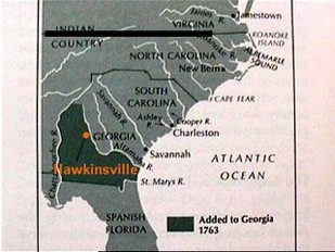
The Ocmulgee River was the boundary line between English and Spanish lands up until 1763, when the English won control over the area. From 1763 until 1819, this area between the Ocmulgee River and the modern border of North Florida was virtually a no man's land inhabited by very few English, a few Spanish settlers seeking refuge from Spanish rule, and the native tribes of the area.
The old Indian trading post, which was a pivotal part of the Spanish explorations, was Old Hartford, where the OWEPS is located and is just across the River from Hawkinsville. Hartford was the first trading post used and bordered by the territories of the Indian, Spanish, French, English, and the United States and remained so until the establishment of Hawkinsville in 1813, just prior to the Spanish ceding Florida to the US in 1819. (Hartford was such an important part of Georgia and American history in so many conflicts and in the victory of obtaining Florida from the Spanish after 300 years of Spanish rule that Hartford was considered for the location of the capitol. It missed by 1 vote becoming the state capitol, beat out by Marthasville, Ga., now called Atlanta.) The vast 'no-man's land' of today's south Georgia, sat virtually uninhabited by Europeans until the very end of the 18th century and first part of the 19th century, wherein towns began to spring forth from tiny remote former Indian or Spanish settlements. Such was the case with Hartford and Hawkinsville. Hartford was quickly becoming an important trade and shipping center with a direct route to Savannah via the Ocmulgee River. However, the sandy marshland of Hartford was a breeding ground for Malaria. Hartford was abandoned in favor of the opposite side of the River where the town of Hawkinsville; named for Benjamin Hawkins, General Superintendent of Indian Affairs; quickly grew to become a major commercial center for cotton, among other resources.
This area around Hawkinsville and Hartford saw fighting between the English and Spanish from 1733 on and off until 1819, and was the Front and the last line of defense for both the English and Spanish. It is here in this centralized location that we find today the amalgamation of Spanish, French and English Alaunt dogs of war.
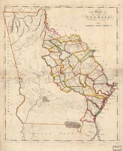
The map above is an 1818 map showing the area of Georgia that was settled. This clearly shows the came boundary line as the 1763 map above with the Ocmulgee River remaining the boundary line some 50 years later. It also very clearly shows the vast 'no man's land' of southwest Georgia.
English Forts 1812
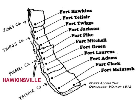
There are the remains of 4 English forts along the Ocmulgee River in Pulaski County, one just 2 miles from the OWEPS, (as is the river), with other English forts along the river in other counties. These forts were actually small outposts, the last line of defense and the staging point for the English during the 'Other War of 1812" or the Patriot War, that was fought in south Georgia and northern Florida.
Right; is a map of the Ocmulgee River through four central Georgia counties, showing the line of English forts built along the boundary line between Spanish and English lands; the Ocmulgee River. The newly discovered DeSoto site is in Telfair County in an area known as 'the forks', where the Ocmulgee and Oconee rivers converge to form the Altamaha River. The 'Forks' can easily be see in the 1763 map above left, and is located in the forts map above at the bottom right angle of the Ocmulgee.
©All Right Reserved
